Showing posts with label transportation. Show all posts

Saturday, May 21, 2011

Los Angeles Busts Out a New Chapter in Planning

California has been on my mind for quite some time now. Not only have I been envisioning what my future residence in California will look like, but I've also been scouring the Interwebs for the "next big thing" in the state's urban planning world. I'm slowly coming to terms with the fact that I won't be able to make a living as a city planner, in any capacity, with only a Bachelor's degree. This, sadly, has been a delusion that I've had to get over rather quickly since graduating from UW. But let's sit back for a second and get a bird's eye view of reality. I figure that if I'm going to make a go at city planning as a career, then I sure as hell better have my finger on concrete projects I could work on when I'm finished with grad school. As they say, if you can dream it, you can do it!

The big picture is that out of California's diverse urban landscapes, the city of Los Angeles holds the most potential as a hotbed of innovative urban planning ideas and projects to engage with. Part of this is just due to the sheer size of LA as America's second biggest city, with nearly 13 million people in the metro area. There are world-class urban planning programs at both UCLA and USC that are of great interest to me. But more importantly, there is an abundance of urban planning projects ripe for the taking mostly because LA's urban planning processes and history have been so thoroughly, utterly fucked up.

The common maxim is that “if aliens were looking down on Los Angeles, they would come to the conclusion that the dominant life-form is the automobile”. Another suggests that even talking about LA as a coherent city is itself specious, that Los Angeles is a series of "72 suburbs searching for a city." How did things get to hell in a handbasket so fast? Why is LA so universally regarded as an urban planning catastrophe?

First, LA was dealt a bad hand simply by experiencing nearly all of its growth as a major city in the immediate post-WWII era. This was a time when the Interstate Highways Commission was pumping billions into brand new freeways. Simultaneously, the Los Angeles Railway, the city's former system of streetcars once among America's most extensive, was being bought out by General Motors and replaced with stinky, polluting diesel bus lines that - surprise! - no one wanted to take. The "locus" of downtown Los Angeles was beginning to become blighted long before the city entered its greatest period of urbanization from the 1960's onward. The dominant entertainment industry, where most of the city's jobs are, was decentralized and favored large studio warehouses in outlying areas, not the kind of centralized factories that solidified the urban centers of most American cities that came of age pre-WWII. These factors encouraged sprawling development patterns for both residential areas and employment centers. And LA's heavenly climate doesn't exactly discourage a car-oriented lifestyle with big, suburban lawns and white picket fences, now does it?

Of course, the suburban dream didn't quite work out as planned for LA. It goes without saying, of course, that LA has America's worst traffic, bar none. The city also has some of the worst social inequality in the US, the infamous Watts and Rodney King riots are only symbolic of this disturbing trend.

However, all is not lost! There are a whole host of new developments pointing toward a sustainable future for LA. Here's a recap of some of the most exciting ones:


1. TRANSIT

LA is already ranked the 3rd best city for transit, according to US News & World Report. Even though most of the native Angelenos I know would never dream of taking public transportation, this isn't to say that there isn't public transit available. Mayor Antonio Villaraigosa has already pledged to accelerate the city's investment in transit, especially rail rapid transit, by building at least $13.7 billion in subways, light rail, and commuter rail in a 10-year time frame, rather than the 30-year plan originally outlined. The expansion of the Expo subway line to Culver City and eventually Santa Monica, two hubs of the perpetually traffic-choked and densely-populated West Side, is the plan's centerpiece.

Additional lines are planned for Westwood/UCLA (Purple Line), the San Fernando Valley (Orange Line), Pasadena to Pomona (Foothill extension), Santa Ana commuter rail, and LAX (Crenshaw corridor). This would be the first time in LA history that the city had three rail projects under construction at the same time.

 Villaraigosa's proposal is probably the most ambitious one for rail/subway transit in the US today. When California voters passed Measure R in November 2008, they agreed to a half-percent increase in sales tax to fund $27 billion in transit in thirty years. So how will LA accelerate these projects when Measure R is only supposed to generate about $3 billion in ten years? Ask the feds for money, and then pay it back when Measure R's funding kicks in completely by the end of the 30-year window. If  this deal is packaged the right way, the federal government could get a significant benefit by lending LA this unprecedented sum of money. Not only will the local economy get a boost (leading to increased federal payroll and gas taxes from the thousands of construction jobs that will be created), but the federal government will also play a hand in solidifying LA's future as a progressive, transit-based city of innovation. Loans to fund this new infrastructure could lure hundreds of thousands of jobs and new residents to the city, whose growth would pay back the loans. China's Special Economic Zones of Hong Kong, Shenzhen, and others have been given a similar treatment over the years, with great success.

LA's ambitious plan to building 30 years of public transit in only 10 years
2. BIKES

The Los Angeles City Council in March approved a plan calling for 1,680 miles of interconnected bikeways. This is a huge event equivalent to building 50 miles of bike lanes per year for thirty years! And it will go a long ways to encourage would-be cyclists previously terrified (with good reason!) by the city's traffic-choked and unfriendly streets, to take to the streets safely.

Map of LA's new system of 1,680 miles of bike lanes and boulevards planned by 2038
This heavy dose of bike infrastructure is also being funded by Measure R, 10% of which was dedicated to bicycle transportation. Here is a link to the full bike plan and more details from GOOD magazine:

The plan promises several changes for L.A. bikers: the Citywide Bikeway System will introduce three new interconnected bike path networks—Backbone (long crosstown routes on busy streets), Neighborhood (short connectors through small streets) and Green (along recreation areas)—throughout the city, a new pledge for Bicycle Friendly Streets will make streets more pleasant for riders and walkers, and a series of education programs and safety policies will help cars and cyclists co-exist. 
Of course, the LA Citywide Bikeway System is still in its conceptual phase and will require a great deal of commitment from the city to actually become a reality. Even so, the plan makes clear and definite the policy choices that Measure R will be allocated into, so even producing this long-range plan is a huge step forward for LA.

So what kinds of infrastructure could the bike plan lead to?

The plan will begin with bike accommodations we regularly see here in Seattle, like "sharrows" and dedicated bike lanes. Later on, bigger projects will include "bike boulevards" and traffic-separated bike lanes that until now have been almost exclusively the domain of cities like Portland, OR and Amsterdam, which I covered here.

Rendering of a "bike boulevard" planned for downtown Los Angeles

Some of the first traffic-separated bike lanes in Southern CA just opened in Long Beach a few weeks ago, and they provide a glimpse (hopefully) of what is to come to the rest of the metro area.

Bike lanes in Long Beach, CA

3. PEDESTRIAN IMPROVEMENTS

Figueroa Street, which runs through downtown and connects with the USC campus, is one of the streets identified as a Backbone corridor, which means its bike and pedestrian improvements will be given highest priority. In all, the street is nearly 30 miles long and is without doubt one of LA's longest and least pedestrian-friendly streets. Copenhagen-based Gehl Architects, of Cities for People fame, are already working on providing bike lanes, improved sidewalks, mixed-use development that embraces street level uses, and what to do with the nearly 545 acres of parking lots within a half-mile of the Figueroa Corridor. More info from GOOD:

The proposals for Figueroa Street are divided into "good," "better," and "best." The entire street would be configured to the "good" specs, with the protected bike lane, more trees, new paving, and general improvements to the pedestrian experience with crosswalk striping and mid-block crossings. The "better" and "best" schemes would be seen at more high-traffic intersections, like near Staples Center and USC's Galen Center.

Vision of a future Figueroa Street landscape. Doesn't it remind you just a bit of Las Ramblas?


An even more groundbreaking proposal comes from three architecture students at Cal Poly: why not ban cars from downtown LA entirely? A baffling 36% of the space of downtown LA is used for parking lots and garages for in-coming commuters. What if that were replaced by more housing, parks, plazas, transit, and all the other things we actually love about cities? Have a look at the slick video they produced for more info:


Downtown Los Angeles from tam thien tran on Vimeo.


Finally, I leave you with an inspirational passage from Tim Halbur of GOOD magazine:

I live in a beautiful old apartment in an historically preserved neighborhood filled with trees. Most mornings, I walk three blocks to the nearest rapid-transit stop and take a 10-minute ride past a major art museum, a couple of beautiful art deco theaters, and several busy shopping and office districts. On alternate days, I bike the four miles, stopping at any one of the many sidewalk cafes along the route before settling into my desk on the fifth floor of a 10-story office tower. 
Would you believe I live in Los Angeles? 
Most people picture sprawling suburbs with deteriorating lawns, framed by minimarts and overshadowed by the Hollywood sign. The corner minimarts are there, but they border old neighborhoods thick with duplexes and other lowrise multi-family dwellings, the kind of dense living quarters that are all the rage among urban planners. In fact, Los Angeles has more people living closer together than Portland, Oregon, the current poster child of urbanism. And depending on where you draw the lines, L.A. is denser even than New York City.

But where Los Angeles differs from those urban cities is that it is really, really big. While the County of New York is less than 23 square miles, Los Angeles County stretches across 4,083 square miles, larger than all of Rhode Island and Delaware combined. And while walkable neighborhoods like mine flourish in many cities across the county, the last 70-odd years of history have decimated the relationships between them. When talking about cities like Cleveland or Pittsburgh, city planners and architects refer to the dead or under-used areas as “broken teeth.” Well, Los Angeles might as well be a washed-up prizefighter, because there are a lot of gaping holes between those pearly whites. 
But all is not lost. Before we revert to old stereotypes about Los Angeles as a Blade Runner-esque dystopia, I’m here to report the good news: The City of Angels is turning away from that imagined future and heading toward a much brighter past.

So even though I'm not chomping at the bit to move to LA just yet - San Fran wins in so many areas it's not even funny :) -  it's good to know that even the most recalcitrant, stubbornly car-oriented cities can still be reborn into somewhere we would actually want to live!

Thursday, March 10, 2011

Has Seattle "Reinvented" Itself?

I don't normally write online comments to newspaper articles, but every so often one will come along that really pushes my buttons. This recent piece in The New York Times is trying to capitalize on the country's almost cult-like fascination with Seattle that's been around since grunge and Sleepless in Seattle. Not only are we responsible for $4.50 mocha frappuccinos and the Dreamliner, we have also "reinvented" our economy through education and cutting-edge urban design, the author argues, in a way that has uniquely saved us from the recession. Did I get that right? Because of course, Seattle likes to think of itself as being so "progressive" it's practically from the future. But are we really? Does the way we run things in the Emerald City really hold true for other cities?


Here's the original article:


As the 2010 Census rolls out, much of the attention of news organizations is focused on the continuing growth of Texas and Florida, but there is much to be learned from the less extreme, but still significant, population growth in less sunny places, like Seattle.
Seattle is one of the few large cities outside the Sun Belt that is growing more quickly than the country as a whole. The city’s growth reveals the benefits of concentrating smart people in dense cities. 
The success of Seattle was hardly foreordained, as it shares much with America’s many declining cities. Like Detroit and St. Louis, Seattle grew as a node of the great transport network, which included canals from Erie to Panama and intercontinental railroads, which enabled Easterners to access the vast wealth of America’s hinterland. 
Seattle’s growth spurt during 1880s coincided with its rail connection to the East. In its early years, the city specialized in providing access to timber and Klondike gold. 
To succeed in the 20th century, American cities needed to do more than help move natural resources, and Seattle moved into manufacturing transportation equipment, natural enough given the vast distance that separated the city from the country’s population centers. 
During World War I, the city’s shipbuilding industry expanded rapidly, andBoeing began as a partnership between a naval engineer and a lumberman. 
Just as Michigan’s forests were part of Detroit’s early success in making cars, since early automobiles — like the carriages that preceded them — had plenty of wood, early planes used light wood and Washington’s timber industry was a boon to Seattle’s airplane industry. William Boeing’s own expertise in wood products helped him to be smart about early airplane construction. 
In 1954 more than half of Seattle’s manufacturing workers labored in the transportation industry. By 1960, Seattle was seen by many as Boeing’s town, but that should have been recognized as a bad omen. 
For 50 years, economists have documented that urban reinvention and entrepreneurship rely on small companies and industrial diversity, not industrial monoliths. 
At the start of the 20th century, Detroit was one of the most innovative cities on earth, with an abundance of small automotive entrepreneurs supplying each other with parts, financing and new ideas. 
As the Big Three rose to dominance, Detroit became synonymous with urban decline. Boeing’s outsize footprint in Seattle set the stage for the city’s 20 tough years after 1960.
Before the industrial revolution, cities were centers of small, smart companies that connected with each other and the outside world. Small companies and smart people are the sources of urban success today. The industrial city now seems like an unfortunate detour during which cities exploited economies of scale but lost the interactive exchange of ideas that is their most important asset. 
As Boeing scaled back its Seattle employment, the city floundered. By 1971, amuch-discussed billboard read “Would the last person to leave Seattle please turn out the lights?”
But there was a crucial difference between Seattle and Detroit. Unlike Fordand General Motors, Boeing employed highly educated workers. Almost since its inception, Seattle has been committed to education and has benefited from the University of Washington, which is based there. Skills are the source of Seattle’s strength. 
Over the last three decades, human capital has become increasingly linkedwith urban growth outside the Sun Belt. 
The ability to attract skilled people was intimately tied to the success of Seattle’s star companies, such as AmazonNordstrom’s, whose strategy of empowering employees was more feasible because those workers were skilled; Starbucks, a coffee chain founded by educators; and Microsoft, which depends on a steady supply of smart software engineers. (Disclosure: I serve on the domestic advisory board of the Bill and Melinda Gates Foundation.) 
A great paradox of our age is that despite the declining cost of connecting across space, more people are clustering together in cities. The explanation of that strange fact is that globalization and technological change have increased the returns on being smart, and humans get smart by being around other smart people. 
Dense, smart cities like Seattle succeed by attracting smart people who educate and employ one another. 
A person’s earnings rise by more than 7 percent as the share of people in his or her metropolitan area with a college degree increases by 10 percent, holding that person’s own level of education constant. Educated neighbors are particularly valuable in dense cities, where contact is more common. 
Skilled people have often chosen to come to already educated cities, and the share of Seattle adults with college degrees has risen to 56 percent from an already high 47 percent in 2000.
Today, Seattle is one of the wealthier and most productive metropolitan areas in the United States. Per-capita personal income is 25 percent above the United States average. Per-capita productivity is 37 percent above the metropolitan average in the United States. That productivity explains why Seattle has grown so robustly over the last decade. 
Seattle has also helped itself by permitting taller structures. That density enables ideas to flow freely. Building up is also an environmentally sensitive alternative to building out, and Seattle’s height helps the city maintain a relatively high level of public transportation use and a relatively low level of carbon emissions. 
Sun Belt sprawl isn’t the only model of modern metropolitan success. Skilled, tall cities like Seattle provide an alternative model of urban growth that emphasizes the creation of knowledge. 
The Seattle model is particularly important, because the ideas created in skilled cities are likely to be the economic mainstay of America in the next century.


I've lived in Seattle for 21 years, and I have lived in both its central city (Capitol Hill) and in suburban areas (Kirkland), graduated from the University of Washington, now working for a Microsoft vendor.

The article is absolutely right to point out the UW and the Port of Seattle as primary ingredients in the success of our fair city. The Port is responsible for nearly a quarter million living-wage jobs in the city, and as Asian economies grow, so do we. Washington is the most trade-dependent state in the US almost exclusively for this reason.

The UW is probably the world's best kept secret among top public universities - it's affordable (less than $8,000 a year in-state tuition), full of top-ranked departments, with 60,000 students packed into a relatively small city neighborhood a 10-minute bus ride away from one of the best and most vibrant downtown areas of the West Coast.

With other factors, the article is a bit off. Luck has definitely been just as much a factor in Seattle's success as entrepreneurship and the "creative class." Microsoft took root in the Eastside suburbs not because a highly educated workforce was ready and available, or because the various infrastructure was secure and well-established. It did so because two of its founding partners, Bill Gates and Paul Allen, had the serendipity of being upper-crust white nerds at an elite prep school working on computers at the precise economic moment (de-industrialization and restructuring in the late 1970s) when doing so could make any decent programmer a millionaire. Starbucks, likewise, emerged at the tail end of the largest crime wave in American history during the late 90's, before- which building sidewalk cafe culture and walkable downtowns (as the early espresso carts before Starbucks did) would have been unthinkable.

Second, the author is quite mistaken if he believes that Seattle's affinity for density is at all responsible for its growth. 75% of Seattle is zoned as single-family neighborhoods. Areas of true high-density living, like one would find in New York, Chicago or San Francisco? There are exactly four of them: Downtown, Capitol Hill, the U District and Belltown, with a combined population of perhaps 100,000 people. Seattle only rezoned areas of South Lake Union and the Denny Triangle for high densities in the past 5-10 years. Before that, these and several other areas were nearly barren and full of parking lots. We just got to the point where major groceries became comfortable locating downtown, which in the US is some kind of accomplishment. How about families with children living downtown? Elementary schools in high-density areas? Compared to a New York, Chicago, or even Vancouver to the north, Seattle shows few of these key signs of life in its "high-density" areas.

Transportation is a severe problem in Seattle, and it is precisely because the city has not adequately invested in truly high-density, sustainable neighborhoods (especially in its middle-class "urban village" areas), that this is the case. The 520 bridge, the Alaskan Way Viaduct debacle,  and our notoriously pothole-plagued streets do not help our case for being paragons of the quality transit infrastructure needed to "win the future", as Obama might say. Need I mention our relatively pathetic light rail system that was rejected in a public vote in the 1960s - it might reach our suburban job centers by 2030, and that's if Tim Eyman doesn't have his way. Outside of a few key corridors, bus service is infrequent and low-quality. In reality, the city's transportation network is a lot like that LA - lots of transit "ridership" on a few highly-trafficked routes, but with the vast majority of commuters trapped in congested freeways with no alternatives in sight.

What is really so special about Seattle?
1. Seattle really is the most educated city in the country, topping even Boston and SF. Do you have a Bachelor's degree? So do 55% of Seattleites over 25. A Master's degree? 1 in 4. 1 in 10 Seattleites has a PhD. If are you are a high-school grad, GOOD LUCK trying to live here.

2. Compared to local incomes, Seattle has some of the most overpriced real estate in the country. The quality of life here makes up a lot of that. Geographically, Seattle is hourglass-shaped with water on all sides. Pretty much anywhere with a "view" - and this is a large chunk of the city - is out of reach to the middle class.

3. If there was one cultural vibe you get from living in Seattle, it is the feeling of being unique and/or apart from the rest of the US. As one of my transplant friends often tells me, this is a "city of the mind." It's like Scandinavia on the Pacific. If you want to study with some of the smartest people on the planet, write code that will change the world, fight global warming, or do business with China, this is the place to do it. Socially, this feeling of constantly being on "the edge" of the next big thing has some negative consequences. The "Seattle Freeze," an ever-present lack of social energy and perceived coldness to outsiders, is something every transplant experiences. Part of it is indeed due to the gloomy weather. As I'm writing, I'm thinking back to the last time I saw sunshine, and the number of weeks it's been is daunting. Another is the dominant upscale, corporate culture of the city that dampens the nightlife on weekdays in most areas. Finally, the high-tech emphasis of our economy (geeks working long hours) and the influence of Asian and Nordic local cultures blends together to create a relative shyness, indifference even, to new people you don't find in other cities.

Tuesday, February 15, 2011

Bike-Only Boulevards: This Would Be Portland's Idea...

In Seattle, late February marks the unofficial start of biking season, because let's be honest, everyone except the most hardcore bike commuters and Critical Mass-types among us has pretty much had their bike sadly rusting away in storage since late October.

So in honor of this, I dusted off my 15-year-old Trek hybrid bike, which had been sitting in my apartment's front doorway almost unused since I moved here in...gulp....September! I'm a terrible cyclist - terrible, terrible, terrible. Bicycling used to be a big part of my life, the one type of exercise I never wanted to quit, the way I discovered new neighborhoods anywhere I went. Hell, a 60-mile ride around Lake Washington was a "training ride" at one point for me not so long ago. I promise to redeem myself this year by doing two things:

1) Train for and do STP, the annual 10,000 rider-strong race from Seattle to Portland. I did STP two years and absolutely loved it!!! There's free food and drinks every 20 miles (a drop in the bucket compared to the 200 miles between the two cities), and my favorite part about it - getting tranced out on my iPod the whole f*cking way there. Wouldn't do it any other way :-)

2) I will devote more space on Green My Fleet to bike-related issues, like bike infrastructure, bike sharing, upcoming rides and events, and bicycle cultures from around the world.

Riding through one of my favorite cities in the entire world - Valencia, Spain
In deference to ultimatum #2, I found a pretty interesting trend that's emerging among the more left-leaning green circles of - where else ?- Portland, Oregon: bike-only boulevards. What's that, you ask? A street where only bikes are allowed - in America??? Impossible. It has to be the psychotic dream of some deranged  hipster twat with chronic anomie and gauged ears! (see below in case you missed the latest episode of Portlandia):


You'd be wrong in thinking that bike-only boulevards are doomed to be an idea of the loony fringe, however. Portland happens to the be the US city with the largest bicycle mode share of 7% (planner-speak for the proportionate ways we get from point A to point B), but it pales compared to bike-friendly cities internationally. European cities take the cake on bicycle population - some 30-35% of all trips are made by bike in most Dutch cities, as well as many cities in France, Germany, and Scandinavia. That most US cities, including Seattle (2% bike mode share), fall way behind Portland is an indictment of our unsustainable transportation system in general.

Portland achieved the success it did by allocating more bike infrastructure - bike lanes, sharrows, bike racks on buses and light rail trains - than any other American city for many years. Portland pioneered the neighborhood bicycle boulevard and the traffic-separated bicycle track that were a first in the US, though hardly elsewhere. A large portion of Portland's large biking population is due not only to its relatively flat geography and outdoorsy culture, but also its 15 neighborhood bicycle boulevards, where traffic is calmed to the point where cyclists almost begin to take precedence over cars.


Recently installed traffic-separated bike track on Manhattan's 9th Avenue, photo courtesy of Seth Holladay of http://www.nycbikemaps.com

Recently, though, Portland's bicycle hegemony may be slipping. Portland was bested by Minneapolis as the most bike-friendly city in America by Bicycle Magazine this past spring. New York City has laid 250 miles of bike lanes in the past three years alone under the partnership between Mayor Michael Bloomberg and DOT Commissioner Janette Sadik-Khan. Meanwhile, bike-sharing systems are sprouting up like weeds across the US, from Washington DC to Denver, San Francisco, and Miami, and Portland is nowhere to be found on this important trend.

Bike-only boulevards represent one of the great bits of uncharted territory for bike infrastructure that Portland and other cities are now looking to tap into. How exactly do you make the transition to a street completely dedicated to bikes? This is something no city in the US can match, and only the densest parts of Amsterdam have any experience with. One of the most important ways to encourage more people to hop on their bikes is to eliminate the threat of riding in traffic, a danger that deters an estimated 60% of "would-be cyclists", that is, people who say they would like to ride their bikes as their primary mode of transport but choose not to.

So by this measure, all of the previous bike infrastructure we've ever experimented with doesn't even come close to meeting people's needs. Bike lanes are often narrow, rarely continuous, and provide zero safety if cars are speeding just inches away from you at 40 miles an hour or more. Most streets lack the space for a dedicated bicycle track, so this option does little for us. Bike paths built on railroad spurs, like Seattle's Burke Gilman, are fun recreational spaces but impractical as commuting paths because they are difficult to integrate with the street network and can only be built where there was once a railroad. Sharrows don't even pretend to give you any space as a cyclist - rather than allocating any street width for bikes, they just paint a bicycle on the asphalt to "warn cars" that bikes might be nearby. Big help that is...

There's already a great deal of evidence in support of bike-only boulevards. The city of Bogota, Colombia, regularly sees almost two million people use its 100-mile plus system of bicycle boulevards that are closed on Sundays as part of its Ciclovia (Spanish for "bike-highway"). Los Angeles copied the event with its own CicLAvia series and likewise saw a huge increase in people out on their bikes. Why? Because the bike-only boulevards remove car traffic and finally make people feel safe being on their bikes.

As cities grapple with how to become more sustainable, we're set with some very big goals to achieve. San Francisco aims to have 20% of its residents moving by bike in just ten years, by 2020. Portland is aiming even higher, 25% bicyclists by the same year. It might just take something otherwise considered radical to hit targets like these. The San Francisco Bike Coalition is lobbying the city's Board of Supervisors to install 27 miles of bike-only boulevards that connect the most important commercial and transit hubs. I can only suspect a proposal like this would cost far less than what the city has spent so far on who knows how many bike lanes.


The bike-only boulevard trend is even spreading to cities as ass-backwards as Seattle. A "neighborhood greenway", borrowing Portland's granola terminology, is planned for the NE 45th St. corridor in Wallingford.

Will these bike-only boulevards work as truly functional transit arteries, and not just a fun Sunday recreational pastime? If the two boulevards installed in London recently are any indication, we needn't worry about that. Bicycle traffic went up 70% in less than a year since installation, which speaks volumes about the difference good infrastructure makes in our transportation choices.

In case you needed any more motivation to be on the look out for bike superhighways, check out this statistic:

According to a report from the Political Economy Research Institute, a think tank based out of the federal Department of Transportation, construction on bike and pedestrian infrastructure creates TWICE the number of jobs per dollar spent than road construction. Take that, Tea Party assholes!

Wednesday, January 26, 2011

So...What Do You Do Exactly?


Every so often, I find an article that hits the nail on the head for exactly what I wish I could say, if only so eloquently. When I was in school at UW and told people that I studied urban planning (don't even get me started with Geography!), I was met with blank stares and mild eye-rolling 90% of the time. You wanna do what now? The other 10% probably has some idea of the profession and assumes you are either a) an architecture school reject or b) a lost hippie who wants to create urban farms to feed organic food to the homeless - don't worry, some of us still do!

Really urban planning is much more simple than that. I want to be able to take people's vague ideas of what a "sustainable" future is supposed to look like and put them into practice. Are you happy with your current lifestyle? Do you worry about pollution and its effect on your health? Do you hate your morning commute and wish there was an alternative to sitting in your car wasting fuel while you idle? Do you wonder why you can't walk to your corner store the way your parents could? Ever wonder how your city will restructure itself due to the recession? Where its jobs will come from? Well, that's where urban planners come in. Because I'm terrible at explaining things like this, I'll leave it to a PhD student at UMaryland whose full article is below:
It happened again, as it invariably does every holiday season. In the midst of spiced eggnog and office holiday parties or visiting with family and friends, I get asked a simple question: “What do you do?” I politely say, “I study urban planning.” And then there’s the inevitable silence as I wait for the quizzical follow-up – “What’s that?” – and another brooding year of Christmas heartache. However, this year something changed. After I uttered my usual phrase, “I study urban planning,” my speech was met with a “Wow, that’s really cool,” and “Ah, that’s interesting, I have a friend who is studying that,” or my personal favorite: “I wish I had gone into planning rather than settle for law school.”  Yes, the field of urban planning was met with unbridled enthusiasm as I made the rounds this holiday season. A Christmas (or Hanukkah) miracle? I think not.
The plain truth is that urban planning is hot. If we take a look at the numbers, according to the Department of Labor, the urban and regional planning field is expected to grow by nineteen percent, from 38,400 jobs in 2008 to 45,700 jobs by 2018. Moreover, quite apparent is that a burgeoning global population has created the need for additional infrastructure including transportation systems, affordable housing, and schools while simultaneously existing infrastructure needs repair and restoration. It is no wonder that U.S. News and World Report included urban planning as one of the fifty best careers for 2011. But this is really just the beginning. 
In his notable work, Planning in the Face of Power, John Forester describes planning or designing as “a deeply social process of making sense together.” Planners, to appropriate the sociologist’s C. Wright Mills language, translate personal troubles into public issues.  Moreover, they help individuals and communities communicate and develop visions for the future based upon shared interests, values, and norms. In a time and place where the prospect of the future seems uncertain, unsettling and even frightening at times, the expertise that planners bring is needed more than ever. In this context, a perfect storm of factors is contributing to an auspicious growth for the field. 
Let’s be straight: Urban planning is and traditionally has been a relatively obscure field in a relatively obscure set of disciplines known as the social sciences (we like to talk things out). In her article “Planning Theory’s Emerging Paradigm: Communicative Action and Interactive Practice,” Judith Innes writes, “There are probably 1,500 people today who hold a planning Ph.D. The proportion of educators with a Ph.D. in planning is steadily increasing.” This was in 1995. Today, my educated guess is there are in the range of 2,500-3,000 people with planning Ph.D.’s and they are in more places than walking the corridors of the Ivory Tower both here and abroad. You can find them in think tanks, NGOs, law firms, and public policy organizations. In terms of academia, one only need take a glance at the Job Bank on the Association of Collegiate Schools of Planning (ACSP) website to see the plethora of faculty jobs available. Indeed, the L. Douglas Wilder School at Virginia Commonwealth University (VCU) alone has announced it will be filling ten or more tenure-track or tenured positions in the coming two years. Ten positions! That’s larger than the entirety of many planning departments, and along with a number of new positions, the field is seeing whole programs commence and become newly accredited including those at Boise State University and the University of Louisville, among others. To put this in perspective for those new to the field, the annual planning conference for academics draws between 400-500 individuals yearly. The field is not large; we aren’t talking a department of history, economics, or political science here. We are talking about a field where there are at present fifty-four openings for urban planning faculty (I counted). 
Why all the activity?  A constellation of factors are at play, including:
• The first full generation of trained planners are on the eve of retirement
• The growing relevance and significance of planning, both locally and globally from Dubai to Detroit reflected by the ascent of wealth and the capacity to build mega-project (e.g. as in Dubai), but also the ascent of poverty resultant from failed public policy, markets, and structural economic forces (e.g. Detroit)
• The growing visibility of planning through media (including this magazine) and the blogosphere thereby precipitating more interest from the general public

As both supply and demand factors continue to incentivize the field, the explicit notion that both individuals and communities are looking for answers and find themselves increasingly reflected in the language of planning, whether tacitly or knowingly, begs the question: What does this emergence mean for how we train planners for the future? It is a question that generations of planners have considered, including Paul Davidoff and Judith Innes. 
Davidoff, regarded as the founder of advocacy planning, described in his 1965 article Advocacy and Pluralism in Planningthe need to broaden the scope of a planners’ education. He wished to widen the focus of planning to include all areas of concern within government. He speaks to the primary role the planner has as a coordinator and suggests that two years of graduate study may be insufficient to broadly train planners for this difficult job. Judith Innes, writing in the mid-1990s, notes the importance of allowing students to take over their own learning processes. She references an anecdote in a teaching workshop she attended which imbued her with a Deweyian lesson, “that learning by doing has far more power than simply learning by reading or listening and that social learning – learning as part of a group effort – has important advantages over the solitary investigation of the lonely researcher.” More recently, Leonie Sandercock contends the need for “therapeutic” processes to transform urban spaces from places of fear (racial, socio-economic, etc) to places of cohabitation and coexistence. Such processes could be structured in helping residents organize meetings in moving from fixed positions to shared interests. These three scholars are but three voices over planning’s lifespan that add to the discourse on planning pedagogy. The ascent of issues such as all things sustainability-related, social justice, and international development planning only contribute to the dialogue on what a planner should be learning.   
Peter Bosselmann, a professor of urban design in architecture, city and regional planning, and landscape architecture at the College of Environmental Design at the University of California, Berkeley, notes that among his students,
There’s an interest in international work right now, which probably has to do with the economy . . . Geographically, China is very important, as is India, and we assume that soon the urbanization of Africa will start becoming of interest. [Topic-wise], the environment is becoming stronger and stronger, especially the forces of nature and how they’re acting on cities, such as the rising of water tables.”
What so many of us love about planning is that it is dynamic. And urgently so. From the growing wealth gaps in the United States and globally, to environmental issues, individuals come to planning because they wish to effect change. We can only hope that as the institution of planning moves into the next decade, planners will be more cogent of their past, their context, and their responsibilities to their craft in embracing this dynamism. No Christmas (or Hanukkah) miracle required. 
Via: Planetizen

Wednesday, January 19, 2011

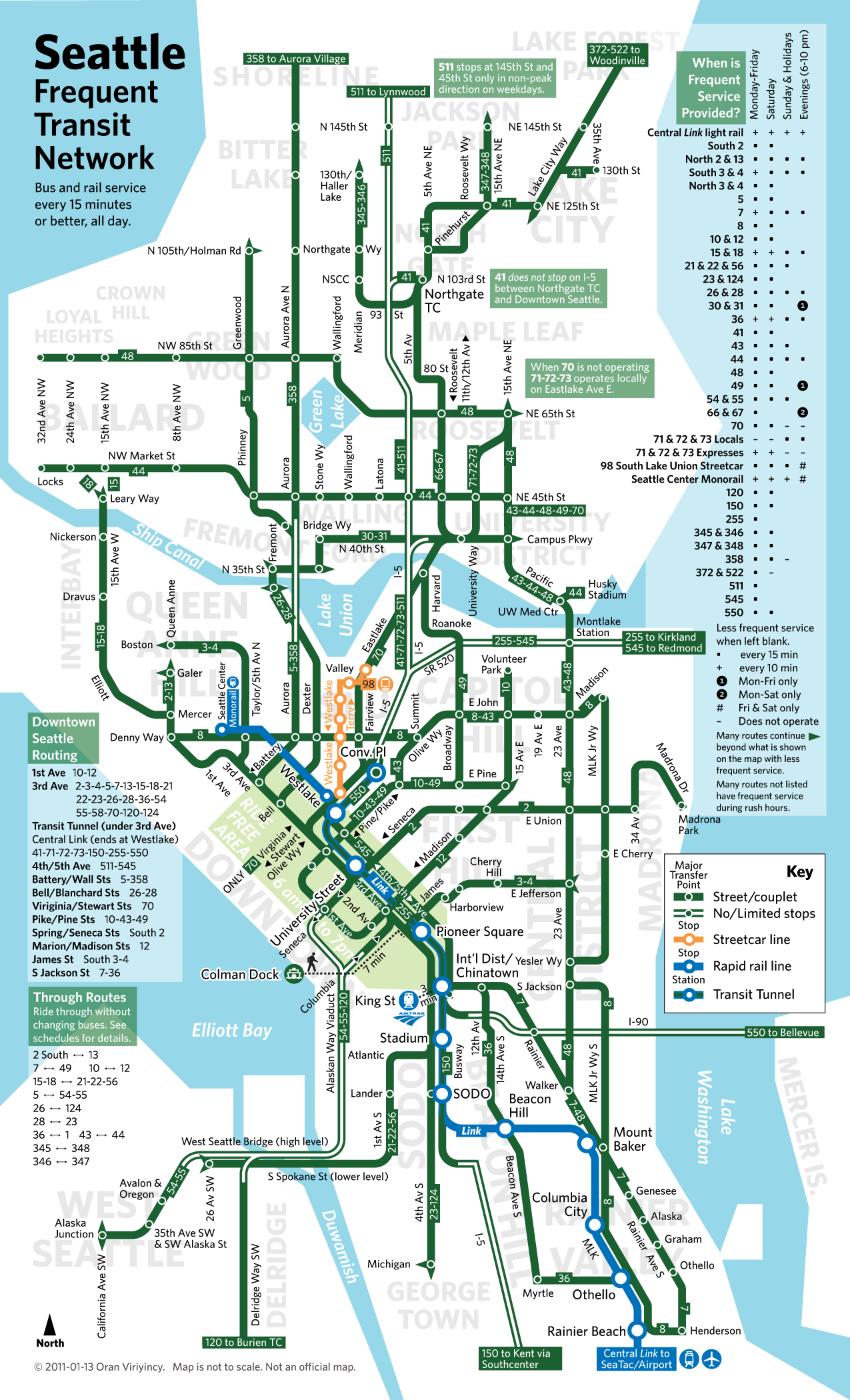
Looking Up Your Bus Route Should Not Be a Chore - Seattle Transit Frequency in One Easy to Use Map

Don't you hate it when you try to look up a bus time, and 10 minutes go by as you try to understand the oh-so-cryptic bus schedule information and route maps? For many of us, it's one of the biggest turn-offs to taking public transportation.

I can remember so many times when I would become trapped in remote areas like Factoria, Kingsgate, or Overlake because I misread a bus route map and caught the wrong bus, only to find that the next bus I was looking for didn't come for another two and half hours!!!

Thankfully, the good people of the Seattle Transit Blog have come to the rescue with this handy map of bus frequency in Seattle. This is an easy-to-use resource that shows all bus routes that have a frequency of 15 minutes or less - that is, they stop every 15 minutes. Realistically, people are only going to use public transit if they don't have to plan every single trip according to its schedule (hence the 15 minute frequency) and if routes are logically placed.

What's not surprising about this map is the extent to which it shows how imbalanced the transit density of Seattle is - Downtown, Capitol Hill, and the U-District pretty much have the greatest number of high-frequency buses, while the rest of the city is left high and dry. Part of this is due to the fact that it's easier to build transit in high-density areas, and part of it is due to budget cuts and bad planning on the part of King County Metro. In particular, the scarcity of frequent buses in West Seattle and Lake City is astonishing - these areas aren't exactly out in the boonies!

I'm sure this map will become my best friend as soon as I start taking the bus more due to the horrendous tolls coming this spring on 520.

Check it out!


Via: Seattle Transit Blog

Thursday, January 6, 2011

Taxis of the Future Soon to Hit New York Streets

The New York City Taxi and Limousine Commission has announced the three finalists for the vehicle they will choose to replace New York's aging taxi fleet. The winning cab will replace a large chunk of over 13,000 cabs that traverse the city. Whichever design is chosen will have a major impact on which green fleet technologies get adopted - New York has the largest taxi market in the US - and which don't.

These are the criteria that will determine the winning bid:
  • Meets highest safety standards
  • Superior passenger experience
  • Superior driver comfort and amenities
  • Appropriate purchase price and ongoing maintenance and repair costs
  • Smaller environmental footprint (lower emissions and improved fuel economy)
  • Smaller physical footprint (with more usable interior room)
  • Compliance with appropriate Americans with Disabilities Act requirements
  • Iconic design that will identify the new taxi with New York City
It will be especially interesting to see how the winning cab stacks up, in terms of fuel efficiency, with the city's current crop of hybrid-electric cabs, or Chicago's CNG (compressed natural gas) cabs that I wrote about here. This is to say nothing of San Francisco's Japanese-made all-electric cabs that received a huge federal grant earlier this year. 

Here are the finalists:
Turkish automaker Karsan's entry, the only cab that is wheelchair-accessible

Ford Transit Connect Taxi

Nissan's finalist


Via: Planetizen

Tuesday, November 23, 2010

It's Absolutely "Mapnificent"

You know you're a geek when you go gaga for something like this.

Mapnificent  is a Google maps interface that plots the areas of a city that are accessible by biking, walking, and public transit within the point of reference you select.

It visually frames the city in a more relevant way for sustainable development. Instead of merely *hoping* that people ditch their cars for bikes and public transit, this could be a tool to assess potential alternatives just by entering your address, not unlike the site Walkscore already famous in the real estate industry.

Here's a couple cool examples from right here in the busiest neighborhoods of Seattle.

Downtown:


Capitol Hill:

University District:

Thursday, November 18, 2010

Taking Public Transportation Can Save You Up to $15,000

This report by the American Public Transportation Assocation, Washington DC-based nonprofit advocacy group, ranks cities in the US by the potential savings a household could have annually in taking public transit versus driving.

Seattle is not exactly known for its stellar record on public transportation effectiveness, but surprise! We are in the top 5! Now if they could only bring the light rail to the UW someday during our lifetime, that would be nice.

If you are a public transportation rider in the city of Seattle, you save an average of $11,350 per year or $946 per month. That's like having a second apartment!

The economy being the way it is, it surprises me that so much of our urban development is still dependent on and dominated by the need to drive absolutely everywhere. Public transit is an expensive investment, to be sure, but it's one that pays back in the end by freeing up consumer incomes for more valuable investments than pumping gas (from third-world tyrants).

Check it out, and see where your city lands on the list!

Sunday, November 14, 2010

That's Why It's 30

A funny PSA just released by the New York City DOT. In addition to making fun of New York sensibilities, it makes its point of sticking to the speed limit short and sweet.


Via: Seattle Transit Blog