It has been a little over a month since I packed my bags, loaded up the UHaul, and set sail for San Francisco. Since then, my main priority has been finding a job (or even a part-time "yob"). So apologies, again, for not maintaining this here blog up to my usual standards. As of this writing, I have not yet found a job but have made some good progress to that end. At the very least I have interviewed for positions far more frequently than I could've ever predicted.
For those of you who're interested, here is a brief update on the job search:
First, the bad news...I have been rejected for the following positions:
So as you can see, not all is lost as the job hunt goes on. The positions that are still in the cards for me are far and away much better fits than those for which I've been turned down. I sometimes forget in the stress of applying to and interviewing for jobs that as much as the employer is interviewing you, you are interviewing the employer to find the best match for you.
The importance of this is easy to overlook when at the end of the day I just need a job to pay my bills. But will it be a job that I enjoy, somewhere I can thrive over the long-term and find real growth opportunities and maybe even a career? Something tells me it was for my own good that the sales and customer service-related positions passed me over. Perhaps they sensed (correctly, I think) that I wanted more out of a job than answering phones all day or mindlessly crunching numbers. Dare I say it, I want a career and not just a dead-end job? So those outcomes can be seen as a blessing in disguise, I suppose.
In the meantime, I cannot praise the temp agencies in San Francisco highly enough. If you ever find yourself unemployed (or under-employed) in a big city like SF, I highly recommend that you get yourself into the local temp agency for an interview.
The first temp agency I met with (who will remain confidential as I am still working with them) was tremendously helpful. I was referred to the agency by my good friend Elyse, who got a kickass job at Pandora with their placement services. She began as a receptionist and has since been promoted twice, first to recruiter, now to events specialist. She has been working there since January, mind you. Elyse is also responsible for helping us find our apartment and has truly been an indispensable resource in helping us getting established here. Love you, Elyse! Her story is one that I think could only happen in a place like San Francisco.
So after Elyse referred me to the temp agency, I applied for several jobs within a few days of getting into town. Not even twelve hours later, I get an invitation to interview with one of their recruiters. Now that's service!
The first woman I met with took one look at my resume and made clear, precise recommendations for several types of positions, such as administrative, sales, or customer service. She told me what to cut (a lot!), what vocabulary to change, and what to embellish for my job search. Another woman I met with had already reviewed my resume and had a position at a biodiesel company already in mind. The position ended up not being available, but the fact that she was able to recommend me for a position in a field I've already blogged about here is a testament to her diligence.
The agency also hooked me up with several days' temp work as an usher at the recent Dreamforce conference at Moscone Center, run by the local software giant Salesforce.com. In case you're wondering what the hell Salesforce is, don't worry...Salesforce is the future, and the future is terrifying! It's basically a sales database system that combines the powers of every social network into one: Facebook, Skype, Twitter, LinkedIn, and Amazon.com, all seamlessly integrated.
Imagine the following scenario: you walk into a Nordstrom's and buy a pair of jeans. Upon ringing you up at the register, the sales clerk registers the transaction into Salesforce, where not only your credit card information, but also your Facebook profile, Twitter feed, blog presence, and nearly every other social footprint online is stored. An inquiring salesperson or advertiser would then be able to search your profiles and "recommend" your next purchase based on the interests you've expressed on your social networks as well as those expressed by any of your hundreds of online friends.
Maybe I'm being paranoid here, but this technology is quite frightening and makes me take pause at how my online presence could potentially be used for sinister purposes. After ushering the VIP section at the Dreamforce keynote address by Marc Banioff, I can tell you that what I've described is merely just the beginning of what Salesforce has in store. Coming soon are internal company Facebook-like social networks, where any employee in a closed network can post company updates, share documents, or even schedule online conferences.
Let's take the next technological leap into the future for a second. Facebook has recently announced a hair-raising new facial recognition technology. You heard right. Technology now exists that can search for and locate your Facebook (and countless other Internet profiles) based on a quick and dirty photograph of your face. See below:
Now let's take a paranoid leap of faith and assume that enterprising companies like Salesforce snap up this technology in a split-second, paying no heed to the public's concerns over breach of privacy. Because you know that's exactly what will happen. Now the sales clerk at Nordstrom's need not have your credit to look up your social presence online. It can now be done by video cameras the instant you walk into the store. Is it just me, or does this not sound exactly like one of the more disturbing scenes from Minority Report?
Run for your lives, children! The future is already here...
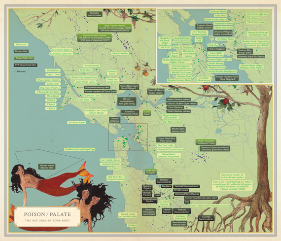
Now for less depressing geekiness. My mom gave me the book Infinite City before I left for San Francisco. It is nothing less than one of the most interesting books I've read in years and was the best possible book I could've read before moving to the city. Infinite City is a collection of maps and accompanying essays that charts the social, economic and cultural history (and future) of San Francisco through the lens of very diverse groups. Written with the premise that every person who lives in the city could write their own infinite series of maps based on their individual life histories (places of residence, watering holes, restaurants or markets they frequent, places they walk their dog) that themselves comprise the fabric of the city. It is a radical concept, that cities are composed of a tapestry of millions of individually situated maps of our livelihoods.
Here are some of the best examples of this type of psychogeography:
Infinite City is the only book I've ever read that truly achieves what a map should as an art form. As a student of geography and GIS, I wish I had been more educated on some of her methods and encouraged to try more or Solnit's wildly imaginative interpretations. Few things are as hard to map as history and culture, for these are nonlinear and fluid concepts. As the author states, any interpretation of our sense of place is situated by our individual experience; there are therefore an "infinite" number of maps that each of us could make of the city, and each would be artistically relevant. Infinite City does a great job of highlighting both the more popular stories/folklore of San Francisco through her maps, as well as those most of us are not brilliant enough to imagine.
Solnit has a keen sense of duality and contradiction, which shows in her cartography. "Poison and palate", the interplay between toxic waste generators and gourmet food destinations and how the two are not at all unrelated. "Phrenology" of the city was another of my favorites. As I finished Infinite City, I was left scratching my head wondering 1) why geography students aren't educated to value maps in the artistic sense; and 2) why aren't there more books like Infinite City for the other great cities of the world! Infinite City is a fantastic read, highly recommended.
That's all for now, folks! I'll be sure to post again when I have more news on the jobs front, if not sooner. To a new life in the Infinite City!
For those of you who're interested, here is a brief update on the job search:
First, the bad news...I have been rejected for the following positions:
- Sales coordinator position at a Facebook-related, early-stage startup in SoMa (rejected after two interviews)
- Customer service position at an events and ticketing late-stage startup in SoMa (rejected after two interviews)
- Executive assistant position at an international non-profit foundation (rejected after one interview)
- Admissions representative at a private university Downtown (rejected after one interview
- Recruiting position at a pharmaceutical staffing agency (declined the position after a phone screen)
Now for the bright spots of the job search, for opportunities still pending:
- Project coordinator position at an affordable housing developer in Civic Center - this is the opportunity I'm most excited about :)
- Policy analyst at an insurance-related non-profit Downtown
- Contracts clerk at a solar company in San Mateo
- Admin at a private university Downtown
- Project coordinator position at a climate change think tank in Berkeley
- Two large temp agencies
So as you can see, not all is lost as the job hunt goes on. The positions that are still in the cards for me are far and away much better fits than those for which I've been turned down. I sometimes forget in the stress of applying to and interviewing for jobs that as much as the employer is interviewing you, you are interviewing the employer to find the best match for you.
The importance of this is easy to overlook when at the end of the day I just need a job to pay my bills. But will it be a job that I enjoy, somewhere I can thrive over the long-term and find real growth opportunities and maybe even a career? Something tells me it was for my own good that the sales and customer service-related positions passed me over. Perhaps they sensed (correctly, I think) that I wanted more out of a job than answering phones all day or mindlessly crunching numbers. Dare I say it, I want a career and not just a dead-end job? So those outcomes can be seen as a blessing in disguise, I suppose.
In the meantime, I cannot praise the temp agencies in San Francisco highly enough. If you ever find yourself unemployed (or under-employed) in a big city like SF, I highly recommend that you get yourself into the local temp agency for an interview.
The first temp agency I met with (who will remain confidential as I am still working with them) was tremendously helpful. I was referred to the agency by my good friend Elyse, who got a kickass job at Pandora with their placement services. She began as a receptionist and has since been promoted twice, first to recruiter, now to events specialist. She has been working there since January, mind you. Elyse is also responsible for helping us find our apartment and has truly been an indispensable resource in helping us getting established here. Love you, Elyse! Her story is one that I think could only happen in a place like San Francisco.
So after Elyse referred me to the temp agency, I applied for several jobs within a few days of getting into town. Not even twelve hours later, I get an invitation to interview with one of their recruiters. Now that's service!
The first woman I met with took one look at my resume and made clear, precise recommendations for several types of positions, such as administrative, sales, or customer service. She told me what to cut (a lot!), what vocabulary to change, and what to embellish for my job search. Another woman I met with had already reviewed my resume and had a position at a biodiesel company already in mind. The position ended up not being available, but the fact that she was able to recommend me for a position in a field I've already blogged about here is a testament to her diligence.
The agency also hooked me up with several days' temp work as an usher at the recent Dreamforce conference at Moscone Center, run by the local software giant Salesforce.com. In case you're wondering what the hell Salesforce is, don't worry...Salesforce is the future, and the future is terrifying! It's basically a sales database system that combines the powers of every social network into one: Facebook, Skype, Twitter, LinkedIn, and Amazon.com, all seamlessly integrated.
Imagine the following scenario: you walk into a Nordstrom's and buy a pair of jeans. Upon ringing you up at the register, the sales clerk registers the transaction into Salesforce, where not only your credit card information, but also your Facebook profile, Twitter feed, blog presence, and nearly every other social footprint online is stored. An inquiring salesperson or advertiser would then be able to search your profiles and "recommend" your next purchase based on the interests you've expressed on your social networks as well as those expressed by any of your hundreds of online friends.
Maybe I'm being paranoid here, but this technology is quite frightening and makes me take pause at how my online presence could potentially be used for sinister purposes. After ushering the VIP section at the Dreamforce keynote address by Marc Banioff, I can tell you that what I've described is merely just the beginning of what Salesforce has in store. Coming soon are internal company Facebook-like social networks, where any employee in a closed network can post company updates, share documents, or even schedule online conferences.
Let's take the next technological leap into the future for a second. Facebook has recently announced a hair-raising new facial recognition technology. You heard right. Technology now exists that can search for and locate your Facebook (and countless other Internet profiles) based on a quick and dirty photograph of your face. See below:

Now let's take a paranoid leap of faith and assume that enterprising companies like Salesforce snap up this technology in a split-second, paying no heed to the public's concerns over breach of privacy. Because you know that's exactly what will happen. Now the sales clerk at Nordstrom's need not have your credit to look up your social presence online. It can now be done by video cameras the instant you walk into the store. Is it just me, or does this not sound exactly like one of the more disturbing scenes from Minority Report?
Run for your lives, children! The future is already here...
Now for less depressing geekiness. My mom gave me the book Infinite City before I left for San Francisco. It is nothing less than one of the most interesting books I've read in years and was the best possible book I could've read before moving to the city. Infinite City is a collection of maps and accompanying essays that charts the social, economic and cultural history (and future) of San Francisco through the lens of very diverse groups. Written with the premise that every person who lives in the city could write their own infinite series of maps based on their individual life histories (places of residence, watering holes, restaurants or markets they frequent, places they walk their dog) that themselves comprise the fabric of the city. It is a radical concept, that cities are composed of a tapestry of millions of individually situated maps of our livelihoods.
Here are some of the best examples of this type of psychogeography:
 |
| The "phrenology" of San Francisco - the city as it reflects within the human psyche |
 |
| Gay bars and endemic butterfly species - a great pairing if there ever was one! |
 |
| Poison vs. Palate - toxic waste sites overlaid ontop of gourmet foodie destinations - "What doesn't kill you makes you gourmet" |
 |
| Old-style movie houses and scene locations from Alfred Hitchcock movies |
Infinite City is the only book I've ever read that truly achieves what a map should as an art form. As a student of geography and GIS, I wish I had been more educated on some of her methods and encouraged to try more or Solnit's wildly imaginative interpretations. Few things are as hard to map as history and culture, for these are nonlinear and fluid concepts. As the author states, any interpretation of our sense of place is situated by our individual experience; there are therefore an "infinite" number of maps that each of us could make of the city, and each would be artistically relevant. Infinite City does a great job of highlighting both the more popular stories/folklore of San Francisco through her maps, as well as those most of us are not brilliant enough to imagine.
Solnit has a keen sense of duality and contradiction, which shows in her cartography. "Poison and palate", the interplay between toxic waste generators and gourmet food destinations and how the two are not at all unrelated. "Phrenology" of the city was another of my favorites. As I finished Infinite City, I was left scratching my head wondering 1) why geography students aren't educated to value maps in the artistic sense; and 2) why aren't there more books like Infinite City for the other great cities of the world! Infinite City is a fantastic read, highly recommended.
That's all for now, folks! I'll be sure to post again when I have more news on the jobs front, if not sooner. To a new life in the Infinite City!


